Spatial Intelligence Arrives in Plan Review
Community development is fundamentally geographic—all projects have unique geographic influences, such as existing infrastructure and location-based regulations. Yet plan review has long occurred in geographic data isolation, forcing reviewers to piece together spatial context from disconnected systems, external tools, and fragmented data sources.
We chose this as a key area to innovate and empower reviewers.
We reimagined plan review—not as a static review of documents, but as a dynamic process embedded with spatial intelligence. As the first and only plan review platform to seamlessly and securely integrate Esri’s ArcGIS® technology, we bring this spatial data directly to where reviewers work.
Reviewers no longer need to leave their workflow to access geospatial data, saving up to 40 minutes per permit. With richer spatial information available instantly, decisions are both faster and more accurate, enabling reviewers and departments to move faster, align more effectively, and approve with confidence.
This represents a fundamental evolution of how local governments lead community growth, grounded in the power of place.

Avolve GIS
Complete site context and a single source of truth, all within one review workspace.
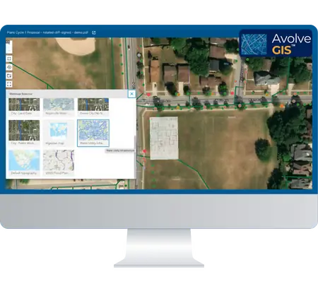
Plan review shouldn’t require piecing together maps and spatial data from multiple systems and tools. Avolve GIS changes this by seamlessly embedding Esri ArcGIS directly into your review workflow. Instantly drop a plan sheet onto a live basemap, rotate drawings to true north, adjust transparency to spot conflicts, and markup issues—right within your review workspace.
Our spatial viewer supports 2D aerial imagery and GIS parcel layers today, with powerful 3D scene visualization, advanced map tools, and expanded data integration arriving regularly through our release roadmap.
The result: Gain instant site context, sharper code awareness, and dramatically faster reviews.
See Avolve GIS in Action
Local government GIS implementations have demonstrated up to 16X return
COMPLETE CONTEXTUAL AWARENESS
Each development is understood within its full geographic and regulatory context.
FASTER PERMIT PROCESSING
Embedded GIS provides instant access to spatial data within the review workflow, speeding up approvals and reducing delays.
MORE INFORMED DECISIONS
Leverage spatial intelligence to drive data-informed decisions to maximize the impact of your existing team and resources.
SUPPORT PREDICTIVE PLANNING
Visualize infrastructure impacts before problems arise, reducing costly rework.
IMPROVED COLLABORATION
Single source of spatial truth eliminating departmental silos.
FUTURE-PROOF YOUR DIGITAL STACK
Access to Esri’s progressive capabilities—from 2D aerial imagery to sophisticated 3D visualization—with every Avolve release.

Avolve is proud to partner with Esri, the global leader in geographic information system (GIS) technology, to deliver transformative, location-aware solutions for government plan review.

This collaboration combines Esri’s market-leading ArcGIS platform with Avolve’s innovative plan review tools, creating a seamless, AI-powered environment that enables local governments to embrace geographic context in their daily workflows and foster thriving communities.
Interested in seeing this powerful integration in action? Watch this recorded webinar where experts from Esri and Avolve demonstrate how integrating Avolve’s plan review with ArcGIS enables teams to visualize projects in their true geographic context for faster, more informed reviews.

Advancing Plan Review with Next Generation Innovation
Avolve is dedicated to advancing local government with seamless, scalable AI support that enhances end-to-end plan review all within one expert plan review solution. We are committed to building AI plan review enriched with the latest technologies from advanced markup functionality and GIS integration, to mobile plan review, or insightful reports and analytics.
Our roadmap brings these capabilities together to transform plan review. Through intentional innovation and quarterly product updates, our continuous improvement delivers unified intelligence—all on a single, seamless platform. This AI plan review provides local government with a way to transition to the ultimate efficiency for outstanding citizen service delivery.


